

Beauregard Parish Towns and Communities
Towns & Communities
Go to Maps and check out all the older areas.
New information graciously submitted by L V Hayes
Abbie Jo - location unknown
BAGGETT - a community on LA 26 about 4 miles southeast of Hoy.
BANCROFT - a community on LA 389 about 9 miles southwest of Bivens and about 3 miles east of the Sabine River. Spikes Cemetery is located about a half mile to the southwest. James David Spikes, 1790-1864, and his second wife, Lucinda Bass, 1812-56, settled in this area in the 1840s. Both are buried in the Spikes Cemetery. James was born in Georgia and lived in Alabama and Mississippi before coming to Louisiana.
BANNISTER - a whistle stop about 1 mile west of US 171/190 and 3 miles north of Sweetville.
BARNES CREEK- a community south of De Ridder on Barnes Creek.
BEARHEAD - a community near Bearhead Creek and LA 109. It is southwest of Singer and northeast of Fields.
BECKWORTH (Beckwith) - site of the US post office used as an address by people listed on the 1860 Calcasieu census who lived in what is now thewestern half of Beauregard Parish. The community was located north of Singer, possibly near where the highway crosses Beckworth Creek; it is currently known as the Beckwith community. The creek and community were probably named after Jonathan E. Beckworth, who was an early settler of the area. He was born about 1780 in Virginia and appears to have died in the 1860s. Jonathan is listed on the first (1840) Calcasieu census, and it appears that he arrived in the area in the 1830s. Beckwith Baptist Church and Beckwith Christian School are located in the area.
BEEHIVE - a community about 3 miles northeast of Singer in the vicinity of the Havens Cemetery.
BIVENS (or Franks) - a community on LA 389 about 7 miles south of Merryville. The Bivens and Franks families settled this area. The Franks Cemetery is located here.
BON AMI - about three miles south of DeRidder on what is now the Singer highway. It was a water stop for the railroad, and , according to people who lived there, had the best water in the world. A saw mill town near LA 27 about 2 miles south of De Ridder.
BRUSHY CREEK- a community east of Bancroft near the Brushy Creek.
BUNDICK - a community on LA 1147 about 1 mile northwest of LA 113 and about 2 miles southeast of Shiloh.
BUNDICK LAKE - a community around Bundick Lake.
CANEY CREEK - a community near the Caney Creek southwest of Fields.
CARSON - a saw mill town on the KCS railroad about 5 miles south of De Ridder. It was built in 1903 by the Central Coal & Coke Co of Oklahoma and probably named after a company official.
CLARK SETTLEMENT - an area bounded by Gene Nelson Road (BPR 442) on the east and south, Clark Cemetery Road on the north, and LA 109 on the north and west. The area was settled by the John Harvey Clark Sr family beginning just after the Civil War. The Archie Clark, Babe Clark, and Dick Clark Cemeteries are located in this area. The Carter Family Cemetery is located just to the south of the area in Calcasieu Parish, and the Smith Cemetery is located just to the west of the area in Beauregard Parish.
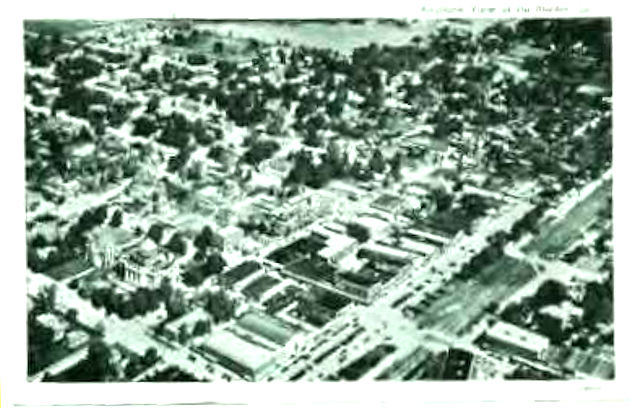
DERIDDER - Parish seat 1950 aerial view the parish seat, located in northern Beauregard Parish about 3 miles from the Vernon Parish line. No community existed here until the KCS railway came through the area in 1897. The site was named De Ridder after a Dutch girl who was kin to one of the investors in the KCS. The town was incorporated in 1903 and became the parish seat after the parish was created out of Calcasieu Parish in 1912. The Beauregard and Woodlawn Cemeteries are located here.
DRY CREEK - a town in eastern Beauregard on LA 113 about 13 miles south of Sugartown. Date first settled unknown, but Burkitt W. Lindseyreportedly built the first school here in 1859. The Dry Creek Cemetery is located about 1 mile to the east-southeast. Lindsey Cemetery is situated about 2 miles to the west-northwest.
DUETTS EDDY (originally DeWitt's City) - a community on the Sabine River south of Bancroft. William Clinton DeWitt and wife Sarah Elizabeth Mims settled there in the mid 1850s. The area came to be known as DeWitt's City and later as Duetts Eddy, apparently because people thought it was named after an eddy in the river. LA highway maps published in the 1950s and 60s had Duetts Eddy on them as a town, but more recent maps do not even show the site.
EDITH - on US 190 about 7 miles east of Ragley.
FAYETTE - location unknown.
FIELDS - a community at the intersection of LA 109 and LA 389. Also called Old Fields and Hyatt, the latter especially after the Hyatt high school was built just southwest of the intersection. The school was named after the Hyatt family, which settled along the nearby Windham Creek in the 1860s. The Hyatt Cemetery is located about 3 miles south of Fields.
FULTON - . The town itself is not there anymore, but record of it existing on maps in the following years: 1911 and 1923. It was located approximatly 2 or 3 miles east of the Highway 190 and Highway 171 intersection at Ragley, Louisiana. It was within a mile of the town of Pearl, Louisiana (now extinct). There was a post office located in Fulton at one time, but is now only a historical location. This area was at one time Imperial Calcasieu Parish, but in 1913 Beauregard was formed encompassing Fulton, LA. At the intersection of US 190 and BPR 151 about 2 miles east of Ragley.
FRANKS - see Bivens.
GAYTINE - about 5 miles southeast of Ragley and 2 miles east of US 171.
GEKOP - at the intersection of LA 12 and BPR 115 (Gimnick Road) about 2 miles southwest of Gordon.
GORDON - on LA 12 about 7 miles southwest of Ragley.
GRABOW (or Graybow) - about 3 miles southwest of De Ridder. A big fight took place there in 1911 at the Doggie Saloon; the incident is also known as the Grabow Riot.
GRANBERRY - between De Ridder and Bon Ami.
GREENTOWN (also Green Town) - a community west of Dry Creek where the Green family settled in the 1850s. William Washington Green Sr, 1829- 65, and wife Martha Hamm, 1829-1900, came to this area from Claiborne Parish, LA. He was originally from Mississippi, she from Tennessee. Oakland Cemetery (also known as Green Cemetery) is located here.
HELME - a whistle stop on the KCS railroad about 6 miles southwest of DeQuincy.
HITE - a whistle stop on the AT&SF railroad about 2 miles southwest of DeRidder.
HOPEWELL - a community around the Hopewell Baptist Church, which is just west of the northwestern end of Bundick Lake. Hopewell Cemetery wraps around the north, south, and west sides of Hopewell Church.
HOY - a sawmill community at the intersection of LA 26 and BPR 297(Smyrna Road) northeast of Bundick Lake. Often called Old Hoy after the mill moved to a new site in Allen Parish. The Hoy Cemetery is located in this area.
HYATT - see Fields
IKES - a whistle stop on BPR 1146 and the AT&SF railroad about 4 miles east-northeast of De Ridder. Lewis Cemetery is in this area.
INSCO - a whistle stop about 1 mile west of US 171/190 and 3 miles north, northwest of Longville.
JUANITA - a whistle stop on the KCS railroad about 3 miles south-southwest of Singer. Good Hope Cemetery is located about one mile to the southwest on LA 109.
JUNCTION - a community at the intersection of US 190 and LA 111 west of DeRidder where US 190 turns south to Merryville.
KERNAN - a whistle stop on the railroad about 2 miles west of Ragley.
KIPLING - about 8 miles northwest of Dry Creek and 1 mile east of Bundick Lake on Bundick Lake Road. Spring Creek Cemetery is located just south of here. In the days of the turpentine camps, there was a large community of blacks and a large cemetery for them. The last evidence of this cemetery disappeared about 25 years ago.
LONGACRE - at the intersection of BPRs 318 and 325 about 1 mile off LA 26 and about 10 miles east-southeast of DeRidder.
LONGVILLE - A saw mill town once the site of one of the largest saw mills in the area and perhaps in the state (or country). The old mill pond is now a well known recreation place with boating, fishing, camping, etc. The town is on US 171/190 about 19 miles south- southeast of De Ridder.
LORETTA - location unknown.
LUDINGTON - a saw mill town about 2 miles north of De Ridder.
MARION - location unknown.
MERRYVILLE - town in northeastern Beauregard Parish. Date of settlement unknown, but apparently in the mid 1800s. Merryville, Merryville Community, and Light House Cemeteries are located here. Hennigan Cemetery is located 2 miles north of Merryville.
MYERSBERG - location unknown.
MYSTIC - a community around the Mystic church on LA 109 between Juanita and Fields.
NEALE - a whistle stop on the AT&SF railroad about 5 miles east-northeast of Merryville.
NEWLIN - a community in the vicinity of the Newlin Cemetery, which is located on Newlin Road about 3 miles northeast of Singer and about 1 mile east of the intersection of LA 27 and Myers Road. Holly Grove Cemetery (black) is also in this area.
OLD FIELDS - see Fields.
OLD HOY - see Hoy.
ORETTA - a whistle stop on the KCS railroad between Singer and De Quincy about 4 miles south of Seale. Oretta Cemetery is located here. Bilbo Cemetery is about 6 to 8 miles northwest.
PEARL - reportedly one mile from Fulton. No trace remains today.
PLEASANT HILL - on US 171 south of De Ridder at the intersection with Pleasant Hill Road. Pleasant Hill Cemetery is located in this area.
PUJO - a whistle stop on the AT&SF railroad and BPR 5 (Grabow Road) between Neale and Shear.
RAGLEY - a community around the intersection of US 171 with US 190. Never a real town to my knowledge, though there's a grocery/gas station and post office at the intersection and a school nearby. Due to current (2003) construction of a four-lane highway, all businesses, the school, and the post office have reportedly been removed. Magnolia Cemetery is located about 4 miles northeast of Ragley.
RANSEY - location unknown.
SEALE - a whistle stop on the KCS railroad about 4 miles south of Juanita.
SHEAR - a whistle stop on the AT&SF railroad between De Ridder and Merryville about 3 miles southwest of Hite.
SHILOH - a community in the vicinity of the Shiloh Cemetery. This cemetery is located on BPR 306 (Old Hoy Road) about 2 miles west of LA 113.
SINGER - a saw mill town that has lasted. Its date of foundation is not known. First parish seat in 1912; however, De Ridder later won a contest to become parish seat by one vote.
SLAYDONTOWN - a community on LA 27 about 6 miles north of Singer.
SMOKY COVE - a community about 3 miles southeast of Juanita.
SPEAR - location unknown.
SUGARTOWN - History - a town at the intersection of LA 112 and 113 in the northeastern corner of the parish about 18 miles east of De Ridder. Reportedly the oldest town in Beauregard, having been founded as early as the 1820s. The dating is uncertain, and it does not appear that any European settlers lived in the area that early. Sugartown Cemetery is located here, and the New Campground and Old Campground Cemeteries are located a couple of miles southeast of Sugartown.
SWEETVILLE - a whistle stop about 1 mile west of US 171/190 and 3 miles north of Insco.
TULLA - a community on Mennonite Road off US 171/190 about 7 miles southeast of De Ridder.
TURPS - a saw mill town about 2 miles south of Gaytine and 2 miles east of US 171.
Abbreviations: AT&SF Atcheson, Topeka and Santa Fe [Railroad] BPR Beauregard Parish Road KCS Kansas City Southern [Railroad]
Contributors: Anthony Burge, Evelyn Cole, Jan Craven and Terry Jackson
References: 1879 Rand McNally & Co World Atlas (part of Rumsey collection). 1897 Rand McNally & Co World Atlas (part of Rumsey collection). David Rumsey map collection (web site at http://www.davidrumsey.com/). W.T. Block, 1996, _Early Sawmill Towns of the Louisiana-Texas Borderlands_, Woodville, TX: Dogwood Press.